
Catch Pins
Not claimedUpload photos
By Ryan Grenadier · Health and fitnessWhy we expect it: A promising private fishing log that turns photos, locations, and conditions into a personal guide for planning future trips.




About
Upload photos. Log your catches. Remember where and when the fishing was good.
Catch Pins brings your fishing photos, saved spots, and catch details together in a private log on your iPhone or iPad. Find your best catches without digging through your camera roll, and revisit the places that worked in similar months and conditions.
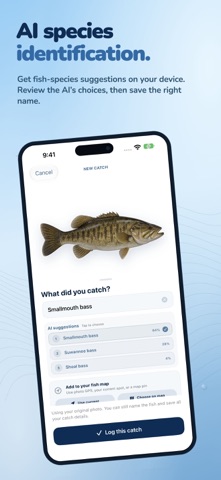
UPLOAD PHOTOS AND LOG CATCHES Choose one photo or a whole batch from Photos, or take a photo in the app. Catch Pins creates a fish sticker and uses on-device AI to suggest the species. Review the suggestions, choose the right name, and add as much detail as you like. If the cutout fails, you can still save the original photo and all your catch details.
SAVE THE SPOT AUTOMATICALLY Catch Pins reads a photo’s GPS location when available and can use your location for a new camera catch with your permission. You can also choose a spot on the map. See the places you’ve fished and the fish you caught at a glance, whether you’re close to home or traveling.
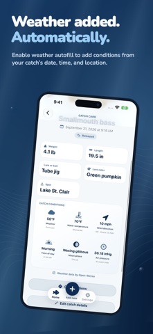
REMEMBER THE CONDITIONS Record weight, length, measured water temperature, lure or bait, water body, and release status. Enable optional weather autofill to add weather, air temperature, wind, and pressure based on the catch’s date, time, and approximate location. Time of day and moon phase are calculated from the catch date.
FIND THE BEST TIME TO RETURN Filter your catches by species, month, weight, length, water or air temperature, pressure, and moon phase. Compare what you caught, where you caught it, and when the conditions worked, then use your own history to plan your next trip.
EXPLORE YOUR FISHING MAP Switch between a visual sticker collection and your private catch map. Explore NOAA depth contours, on by default and easy to turn off, in supported U.S. coastal, Great Lakes, and inland waters. Depth contours are informational and not for navigation.
PRIVATE BY DESIGN Every catch lives on your device. Photo processing and AI species suggestions run on your device, too. No account, ads, analytics, tracking, subscriptions, or in-app purchases. Export and restore a backup of your photos, saved spots, and catch details when you need it.
Weather is optional and off by default. Depth contours are on by default; you can turn them off with the map’s Depth button. Weather requests send an approximate catch coordinate, date, and hour to Open-Meteo. Depth requests send the visible map bounds to NOAA. These services receive the request IP address; your photos and catch records are never sent to them. Apple Maps supplies map imagery and location search.
Species suggestions can be wrong. Review the name and use a trusted local resource when accuracy matters.
People rate it
Sign in to rate this app. Honest is what counts.
No ratings yet. Tried it? Be the first to rate it.