
Deed to Map: Metes & Bounds
Not claimedRead the boundary description on your deed and see your land on the map
By Tigran Barseghyan · TravelWhy we expect it: Clear, careful description and on-device closure checks make a genuinely useful tool for landowners and surveyors.


About
Read the boundary description on your deed and see your land on the map.
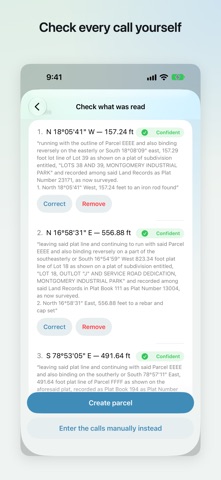
Deed to Map reads US-style metes and bounds, the bearings and distances written on deeds, surveys, plats and annexation ordinances, and draws the parcel they describe. Photograph the page, check what was read, and watch the shape appear over satellite imagery.
Everything happens on your device. Your deed is never uploaded.
READ YOUR DOCUMENT - Photograph a page, or import a photo or PDF you already have - Text recognition runs entirely on your iPhone - Review every call before anything is drawn, and correct it by hand where the paper is unclear
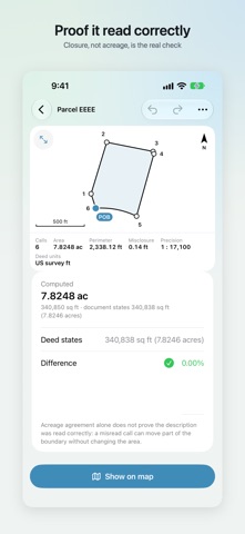
CHECK THAT IT READ CORRECTLY - The app walks the calls and tells you whether the description closes - See the misclosure in feet and the precision as a ratio - Compare the computed acreage against the acreage your deed states - When a description does not close, the app names the call most likely at fault
Closure is the real check. A misread call can move part of a boundary without changing its area at all, so the app treats closure, not acreage, as proof that it read your document correctly.
WRITTEN THE WAY DEEDS ARE WRITTEN - Quadrant bearings such as N 45°30' E, and azimuths, including azimuths measured clockwise from true south as Hawaii descriptions are written - Curves by radius, arc, chord and delta - Feet, US survey feet, meters, chains, rods, poles, perches, links and varas - Magnetic bearings corrected for the year of the survey - Bearings are shown exactly as your document wrote them
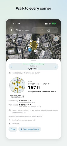
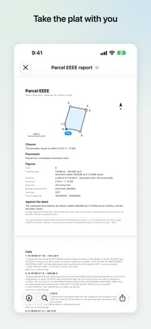
SEE IT ON THE GROUND (Pro) - Place the parcel on satellite imagery from printed coordinates, an address, your GPS position, or by hand - Walk to each corner with live GPS accuracy - Measure distances and areas on your land - Check whether a spot is inside your boundary - Export to KML, GPX and CSV - A PDF report of the plat, every call and its closure
FREE AND PRO Reading your deed is free and always will be: scanning, recognition, the review screen, the drawing, the acreage and the closure check. You can confirm the app read your document correctly without paying anything.
Pro is a one-time purchase. Not a subscription. Nothing to renew and nothing to cancel.
WHAT THIS IS NOT This is not a land survey and has no legal standing. It draws what your document says, at the position you choose. Boundary disputes, construction and property transactions require a licensed surveyor.
WHERE IT WORKS Deed to Map reads US-style metes and bounds. A document written under a different cadastral tradition will usually not be readable. PLSS aliquot descriptions such as the NE1/4 of the SW1/4 of Section 14 are not metes and bounds; the app says so rather than guessing.
People rate it
Sign in to rate this app. Honest is what counts.
No ratings yet. Tried it? Be the first to rate it.