
Fishing Spots Near Me: Tides
Not claimedFishing Spots Near Me puts 3,400+ NOAA coastal stations on a map near you and tells you…
By Mijanur Rahman · LifestyleWhy we expect it: Clear, careful listing with a useful tide-and-bite focus, though its audience is limited to US coastal anglers.




In short
Fishing Spots Near Me shows NOAA coastal stations on a map and rates each one as Prime, Fair or Slack for fishing. Each spot lists tides, and Pro adds live water temperature, wind and current data. It is aimed at anglers on US coasts, and it stands out for showing predicted and observed water levels side by side.
Summary by Debuts, based on the App Store listing.About
Fishing Spots Near Me puts 3,400+ NOAA coastal stations on a map near you and tells you in one word whether it is a good time to fish there: Prime, Fair or Slack. Tap any spot for its tides, live water temperature, wind and current.
NO ADS. NO ACCOUNT. The basics are free. Pro is a monthly or yearly plan, or one Lifetime payment if you never want a subscription.
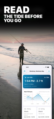
FREE FEATURES • Map of every NOAA coastal station, with the 2 spots nearest to you free • Search by town, beach, pier or bay • Bite rating for every spot: Prime, Fair or Slack • Next high and low tide with a live countdown • 16-hour tide curve with heights, daylight band and sunrise/sunset marks. Hold and drag to read any time • Today and tomorrow tide table • Sunrise, sunset and moon phase • Home Screen widget and Apple Watch app • Times shown in the spot's own time zone. Dark mode. Works offline with the last saved data
FISHING SPOTS PRO • Every spot on the map, and unlimited saved spots • 7-day tide table and 30-day calendar with the month's biggest highs and lowest lows marked • Best bite windows: the exact hours when the rating is Prime • Live water temperature, wind and observed water level from the nearest NOAA sensors • Tidal current speed, direction and the next slack window • Tide alerts: a notification 15 min to 2 hours before any high or low tide • Full 24-hour tide curve • Lock Screen widgets and Apple Watch complications
WHY OBSERVED WATER LEVEL MATTERS Predictions can miss by a foot in wind or storm surge. The app shows the predicted height and the real sensor reading side by side.
Data: NOAA CO-OPS (tidesandcurrents.noaa.gov). US coastal stations only. Ratings are estimates based on tide flow, wind and daylight. Not for navigation.
TERMS AND PRIVACY Terms of Use: https://mrsoftit.com/fishingspotfinder/terms Privacy Policy: https://mrsoftit.com/fishingspotfinder/privacy
People rate it
Sign in to rate this app. Honest is what counts.
No ratings yet. Tried it? Be the first to rate it.
More Lifestyle apps
Best new Lifestyle apps this week askoraAI 회상 노트
 Familjekalender – familjens årFamiljekalender är en delad kalender för hela familjen, där varje dag kan bära ett foto…
 My Anime TrackerAnime watch order, no guesswork.
 WatchLux: Animated Watch FacesOver 750 animated watch faces for Apple Watch and Wear OS
 SCNT ControlSCNT conecta tu teléfono con tu difusor de aroma por Bluetooth y te da el control…
 Sakinah: Quran, Adhkar & DuaSakinah brings the Qur'an, the prayer and daily remembrance together in one calm app, in…