
GPS Tool Ultra-Coordinates
Not claimedGPS Tool Ultra is an all-in-one GPS toolkit for anyone who works with coordinates —…
By 丽丽 许 · Travel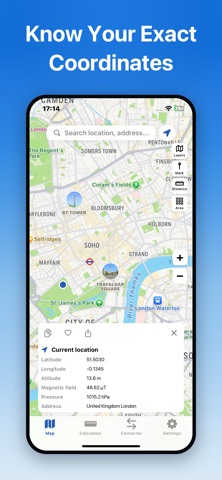


About
GPS Tool Ultra is an all-in-one GPS toolkit for anyone who works with coordinates — surveyors, engineers, hikers, geocachers, pilots, and outdoor professionals. Measure distance and area on an interactive map, convert coordinates across 5 professional formats, and run precise geodesic calculations — all in one app, with your data processed on your device.
ACCURATE GPS POSITIONING • View your current coordinates in real time with latitude, longitude, and altitude • Built-in barometer and magnetometer support: live atmospheric pressure (hPa) and magnetic field (µT) readings • Search any address or place name, or jump straight to a coordinate pair • Tap the map to drop markers and read exact positions
MEASURE ON THE MAP • Distance: multi-point path measurement with live total length • Area: polygon measurement with perimeter display at the same time • Save, copy, and share any measurement result instantly
PROFESSIONAL CALCULATOR • Distance between two or more points — choose Haversine for speed or Vincenty for highest geodesic precision • Polygon area via spherical line integration • Initial and final bearing (azimuth) between two points • Geodesic midpoint between two coordinates
5-FORMAT COORDINATE CONVERTER Convert instantly between: • Decimal Degrees (DD) • Degrees Minutes Seconds (DMS) • Degrees Decimal Minutes (DMM) • UTM (Universal Transverse Mercator) • MGRS (Military Grid Reference System) Plus built-in length units (m, km, mi, ft, nmi) and area units (m², ha, acre, km²) converters.
WORKS FOR YOU • Favorites: save markers, measurements, and conversions into organized collections • Copy any result to the clipboard or share via the system share sheet • Adjustable precision (2–6 decimal places) and default units • Dark Mode support, English and Chinese localization • Unified WGS84 datum across the entire app
ONE-TIME PURCHASE — OWN IT FOREVER • Pay once and get every tool: all 5 coordinate formats, all calculators, all measurements • No subscriptions, no in-app purchases, no ads • Full functionality from the first launch — nothing locked, nothing gated
PRIVACY FIRST — GDPR READY • All location, sensor, and conversion data is processed locally on your device • Export your data or withdraw consent anytime in Settings • No account required
PERFECT FOR • Surveyors and field engineers marking boundaries and measuring land • Hikers, hunters, and anglers recording waypoints and campsites • Geocachers entering MGRS or DMS coordinates • GIS professionals converting between UTM, DMS, and decimal formats • Pilots and navigators computing bearings and midpoints
Download GPS Tool Ultra — pay once and carry a complete GPS workstation in your pocket.
People rate it
Sign in to rate this app. Honest is what counts.
No ratings yet. Tried it? Be the first to rate it.