
Hitrekk
Not claimedHitrekk keeps your hikes on a 3D map
By Robin Stokkel · Travel


About
Hitrekk keeps your hikes on a 3D map. Import the walks you have done, plan the ones you want to do, record a hike live, and take the map with you for places without signal.
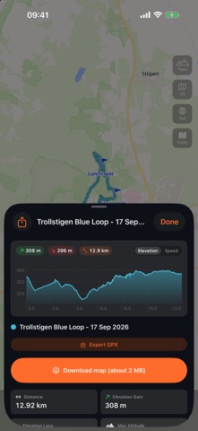
IMPORT AND PLAN Open a GPX file from Files, Mail, AirDrop or any share sheet and Hitrekk asks whether it is a hike you did or a route you want to hike. Recorded hikes get distance, elevation gain and loss, moving time, rest time, pace and speed. Planned routes are drawn dashed on the map and wait in their own list until you walk them.
RECORD LIVE Start a hike from the map or from a planned route. Hitrekk records your track and shows distance, moving time, pace, elevation gain and a live elevation profile. On a planned route it shows how far along you are, how much is left, and when you have drifted off the line. Recording continues with the screen off or another app in front, and a Live Activity on the lock screen and in the Dynamic Island keeps the numbers in view. Pause and resume, drop waypoints with a long press, and stop when you are done. If the app is closed in the middle of a hike, the track is recovered on the next launch.
MAPS A 3D terrain map with relief shading, OpenTopoMap with contour lines, satellite imagery and a hiking trails overlay. In Norway, Sweden, Switzerland, Germany, France and the United Kingdom the national mapping agency's own map is offered as well.
OFFLINE Download the map for a route plus one kilometre around it before you leave. One button says which map it will store and how large the download is.
PHOTOS Add photos from your library and they are placed on the map where they were taken, attached to the nearest hike.
TRIPS AND SHARING Group hikes into a trip and frame them on the map together. Share a trip, a single hike or your whole map with a link that opens in any browser. Export any hike or trip as a GPX file, waypoints included.
ACCOUNT Sign in with Apple, Google or email. Routes and photos sync between iPhone, iPad and hitrekk.com, and a copy stays on the device so the app opens without a connection.
Hitrekk shows no ads and contains no analytics or tracking software. Your location is used only while a hike is being recorded.
People rate it
Sign in to rate this app. Honest is what counts.
No ratings yet. Tried it? Be the first to rate it.