
HooldusR
Not claimedHooldusR is a forest navigation app for finding and verifying stands that may need…
By Oleksandr Borysenko · TravelWhy we expect it: A clearly described, privacy-respecting forest survey tool that gives Estonian foresters a practical field companion.


About
HooldusR is a forest navigation app for finding and verifying stands that may need maintenance cuttings. It is developed at Tartu Observatory, University of Tartu.
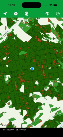
The app draws a map layer derived from remote sensing data covering the whole territory of Estonia. The layer highlights places that should be checked on the ground for maintenance cutting. You navigate to a highlighted stand by GPS, inspect it in situ, and record what you found without leaving the map. MAP COLOURS Highlighted areas are coloured by the year the analysis was produced: ⢠Red â produced up to 2023 ⢠Orange â area updated in 2024
WHAT YOU RECORD At your exact position you save one of three values: ⢠Correct â the stand does need a maintenance cutting, as the analysis indicated ⢠Incorrect â the analysis flagged this stand, but no cutting is needed ⢠Missing â a cutting is needed here, but the analysis did not flag it
Each observation stores the date, your coordinates and an optional comment.
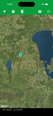
IN THE FIELD ⢠Live GPS position with coordinates shown to six decimal places ⢠Standard or satellite base map, switched with one tap ⢠Hide the analysis layer to read the base map underneath ⢠Saved observations drawn on the map as green, red and yellow markers ⢠Delete an observation recorded by mistake ⢠Export the whole survey as a CSV file and send it from your phone
YOUR DATA STAYS YOURS Observations are stored in a database on your device. Nothing is uploaded, there are no accounts, no analytics and no advertising. Your survey leaves the phone only when you export it and choose where to send it.
COVERAGE The remote sensing layer covers the territory of Estonia. Elsewhere the app works as a plain map and will still record observations, but no analysis layer is drawn.
People rate it
Sign in to rate this app. Honest is what counts.
No ratings yet. Tried it? Be the first to rate it.