
Offing Mediterranean: Charts
Not claimedOffing is a logbook that writes itself
By Luis Carvajal Hoyos · TravelWhy we expect it: A thoughtfully written offline sailing companion with clear, practical value for Mediterranean sailors.



About
Offing is a logbook that writes itself.
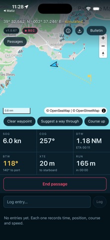
Before you cast off it tells you where to anchor and how much water there is. Under way: the bearing, the distance and the time of arrival, with a suggested line that stays off the land. By the time you tie up again, the passage is already written.
BEFORE YOU GO · Tap anywhere on the chart and it tells you what is there: anchorages, harbours, marks, depth and seagrass meadows. · Marine bulletin and sea state: wind, waves, period and water temperature. · Download the area in port and the chart works just the same ten miles offshore, in airplane mode.
UNDER WAY · Bearing to waypoint, distance, cross-track error and time of arrival. · A suggested route that stays clear of land, in legs: the bearing points at the next waypoint and the ETA gives you both, the leg and the destination. · Chart course up, like a plotter. Or north up, if you prefer. · The passage keeps recording with the screen off and the phone in your pocket. · If you forget to stop and the track wanders inland, it warns you and closes the passage.
APPLE WATCH · Bearing, speed and distance on your wrist, without leaving the helm. · Start and stop the passage from the watch. · With no watch, the app works exactly the same.
THE LOG · Every trip keeps its track, its miles, its duration and its times. · Entries saved with the time and the position where you wrote them. · Photos filed inside that day's passage. · Your logbook as a PDF and your passages as GPX, whenever you like.
WHERE IT WORKS · Nautical chart: the Mediterranean, from Gibraltar to Turkey and from North Africa to the Gulf of Lion. The Canary Islands are not included. · Wind, sea and marine forecast: anywhere in the world. · Official bulletin: Spain (AEMET) and Portugal (IPMA), plus official warnings in 27 European countries. Everywhere else, a forecast built from model data and labelled as such. · Depth: European seas. Seagrass and marine reserves: the Balearic Islands.
NO ACCOUNT, NO SUBSCRIPTION You pay once. No subscription, no account, and we do not even ask for your email. Your passages stay on your iPhone and are not uploaded anywhere. And because the log is also kept in the phone's Documents, it travels in your backup without you doing anything.
IN PLAIN WORDS This is not a navigation system. The charts come from OpenSeaMap and OpenStreetMap, and the depths from EMODnet: a model on a grid of about 115 metres. Between one sounding and the next there is room for a rock. It is an aid, not an official nautical chart, and nothing here is corrected by a hydrographic office. Always carry the official chart on board, and the navigation equipment the regulations require.
People rate it
Sign in to rate this app. Honest is what counts.
No ratings yet. Tried it? Be the first to rate it.