
ScoutWx
Not claimedScoutWx puts every NEXRAD and TDWR weather radar in the United States and about 140…
By Drake Apps, LLC · UtilitiesWhy we expect it: Detailed radar coverage across the US and Europe, with clear product explanations, makes this a strong debut for weather enthusiasts.




In short
ScoutWx is a utilities app that shows US NEXRAD and TDWR radars plus about 140 European radars on a full-screen map, with NWS storm tracks, alerts, lightning, GOES satellite imagery and forecast models. It suits people who follow severe weather closely. One notable feature is that every tilt is shown at each radar's own resolution, with frames that wait to draw in full before playback.
Summary by Debuts, based on the App Store listing.About
ScoutWx puts every NEXRAD and TDWR weather radar in the United States and about 140 radars across Europe on a full-screen map, at every tilt and at each radar's own resolution, minutes after each sweep, with the National Weather Service's storm tracks, every NWS alert and live lightning on top. GOES satellite imagery and 15 forecast models loop on the same map.
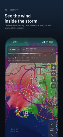
PRODUCTS • Reflectivity: super-resolution base reflectivity at every tilt, the radar's own composite, and TDWR long range • Velocity: NWS-dealiased base velocity, Level II velocity at every tilt, storm-relative velocity with the NWS storm motion or your own, and spectrum width • Dual-pol: differential reflectivity (ZDR), correlation coefficient (CC), differential phase (PHI), specific differential phase (KDP) and hydrometeor classification • Precipitation: one-hour, three-hour, 24-hour and storm-total rainfall, and rain rate • Other: vertically integrated liquid (VIL) and enhanced echo tops • U.S. mosaic: MRMS reflectivity, rain rate and totals, hail size, rotation tracks, echo tops, VIL and lightning
EUROPE The EUMETNET OPERA mosaics (composite reflectivity, precipitation rate and one-hour rainfall) and the radars of 20 countries, each with the products and tilts it sends.
TILTS AND LOOPS Step through every elevation the radar is scanning. SAILS and MRLE rescans of the lowest tilt are in the loop. Play, pause, step or drag along the timeline, up to 120 scans long. Playback waits for each frame to draw in full.
STORM TRACKS The NWS's storm tracking on the selected radar: where each storm has been and where it is forecast at 15-minute steps, with hail, mesocyclones and tornado vortex signatures. Tap a storm for its motion, hail, core and rotation.
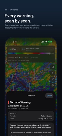
ALERTS Every NWS alert, drawn as it stood at each scan: tornado, severe thunderstorm and flash flood warnings, tornado and severe thunderstorm watches, SPC mesoscale discussions, WPC precipitation discussions, and the hurricane, flood, winter, fire, heat and marine alerts issued by county or zone. Tap inside one for the threat, the timing and the full text.
SATELLITE AND LIGHTNING GOES-East and GOES-West imagery of the Americas, a new image every 5 minutes: infrared with the coldest storm tops in color, cloud cover in white over the map, visible by day and water vapor. Lightning from the same satellites, usually about a minute after each flash, draws over any product, each scan with the 5 to 30 minutes before it.
FORECAST MODELS Loop the GFS, ECMWF, AIFS, AIGFS, ICON and GDPS worldwide, the HRRR, NBM, RDPS and HRDPS over North America, the GEFS, ECMWF and AIFS ensembles, and the HAFS hurricane models. Pressure and precipitation by type, temperature, wind and gusts, rain and snow totals, CAPE, helicity, 500 mb vorticity, the jet and ensemble spaghetti, out to 16 days, with earlier runs a tap away.
READ ANY POINT Press and hold anywhere for the value under the crosshair, the hydrometeor class or range folding, and the beam height there. Drag the crosshair, or let it follow the loop.
STATIONS AND PLACES Live readings from personal weather stations on the Dank Weather network and from airport METARs show the conditions on the ground under the storm. Save the places you care about and jump to them. Highways, county, state and country lines and place names are drawn over the radar.
IPHONE, IPAD AND IPHONE DUO Portrait and landscape, and full screen at a tap. On iPhone Duo the open screen becomes two pages: one map across both, the map beside the product list, or two maps in step, each with its own radar, product or model. Units are yours to choose. Your location and saved places stay on your device.
People rate it
Sign in to rate this app. Honest is what counts.
No ratings yet. Tried it? Be the first to rate it.
More Utilities apps
Best new Utilities apps this week Vodoalarm: vodostaji BiHVodoalarm javlja kad tvoja rijeka naglo raste, pa ne moraš stalno gledati vodostaje
 Rokey: Romanian KeyboardType Romanian without worrying about diacritics
 Vibe Island: AI Agent MonitorVibe Island is a command center for the AI coding agents running on your Mac
 Private AuthenticatorPrivate Authenticator keeps your two-factor authentication codes on your own Apple…
 Photo Clean: Photo CleanupA crowded camera roll?
 Songbird AlarmWhat if the morning didn't have to start with a loud noise?