
Bitegrid: Fish Forecast & Map
Ei lunastettuFlorida coverage
Tekijä: Upswing Projects LLC · Terveys ja kunto




Lyhyesti
Bitegrid: Fish Forecast & Map gives hour-by-hour fishing forecasts for 15 Florida species, combining tide, moon, pressure, light and wind into a single Bite Score out of 25. It is aimed at anglers fishing Florida waters and includes lidar depth shading, charted reefs and channels, and NOAA tide data. It stands out for its offline access to recently loaded forecasts and its no-account, no-ads design.
Debutsin tekemä tiivistelmä App Store -listauksen pohjalta.Tietoa
Florida coverage. BiteGrid scores every hour of the day for the fish you're after — tide, moon, pressure, light and wind combined into one Bite Score out of 25 — so you spend your time on the water during the best windows.
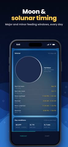
KNOW WHEN THEY'LL BITE - Hour-by-hour Bite Score for 15 Florida species, from redfish, snook and seatrout to tarpon and offshore pelagics - 41 forecast spots statewide — BiteGrid opens on the one nearest you - See why each hour scores the way it does: tide movement, solunar feeding windows, pressure trend, light and wind - NOAA tide predictions, water temperature and National Weather Service marine alerts - Plan ahead with a multi-day outlook, or look back at how past days played out
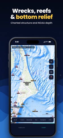
KNOW WHERE THE WATER DROPS OFF - High-resolution lidar depth shading and contours along much of Florida's coast, with more areas being added - Spot finder highlights holes, bars and drop-off edges - Charted reefs, wrecks and rocks, the Intracoastal Waterway, channel markers and boat ramps - NOAA depth layer and bottom relief for the bigger picture - Enclosed bays and lagoons shaded edge to edge — Indian River, Mosquito Lagoon, Tampa Bay, Charlotte Harbor, Biscayne Bay and more
SIMPLE AND PRIVATE - No account, no sign-in, no ads - Your location stays on your phone — it's only used to open on your area - Recently loaded forecasts stay available when you lose signal
NOT FOR NAVIGATION. BiteGrid's charts, depths and spots come from public data (NOAA, NCEI, USGS) and can be incomplete or out of date. Always use official charts, your depth sounder and current marine forecasts, and follow Florida FWC fishing regulations.
Terms of Use: https://bitegrid-phi.vercel.app/terms.html Privacy Policy: https://bitegrid-phi.vercel.app/privacy.html
Ihmisten arvio
Kirjaudu sisään arvioidaksesi tämän sovelluksen. Rehellisyys on tärkeintä.
Ei vielä arvioita. Oletko kokeillut sitä? Anna ensimmäinen arvio.
Lisää Terveys ja kunto-sovelluksia
Viikon parhaat uudet Terveys ja kunto-sovellukset Orbit: Self-Care Habit TrackerYour healthy choices deserve more than a checkmark
 Wellbeing: Digital WellbeingBillions of people spend more time scrolling than they want to
 Vigia: meds & family healthVigia keeps your health and your family's in order: a child, a parent, a partner
 Pinfall: Bowling StatsPinfall is the bowling score tracker for league bowlers who want to get better, not just…
 Nuchronic: Energy & SymptomsTrack your energy and symptoms in seconds
 Drrreong - Sleep RecorderWhat did your night sound like?