
Nadhir
Non revendiquéeNadhir is an independent app
Par MOHAMED MEHDI BOURAHLA · UtilitairesPourquoi nous l'attendons : Clear official sourcing, offline survival guidance and commune-level alerts make this a strong, useful debut.


En bref
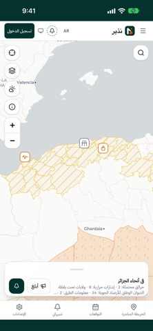
Nadhir is an independent utilities app that puts Algeria's hazards on one map, including wildfires, weather warnings, road closures and earthquakes. It is for residents who want alerts for their commune, with an optional account for watch zones and offline survival guidance. One notable feature is that following a commune never shares the user's exact position.
Résumé par Debuts, d'après la fiche de l'App Store.À propos
Nadhir is an independent app. It does not represent any government entity.
Nadhir brings Algeria's hazards onto one map and alerts you about your commune.
What Nadhir shows: • Wildfires: satellite detections and Civil Protection bulletins. • Weather: warnings from the national weather office (ONM) and fire danger. • Roads: closures and traffic information. • Earthquakes and other hazards.
Alerts: • Pick one or more communes to get their alerts, no account needed. • Turn on "Also follow where I am" and the phone works out its commune and subscribes to its alerts. Following never sends your exact position. • With an account, create watch zones around your home or work.
Survival mode: • Pre-approved guidance that works offline, emergency numbers (14, 1070, 112), and a message to reassure your family.
Citizen reports: • Report a fire or a closed road. A report is published after it is checked, without your name or photo.
Official sources: • Weather warnings: Office National de la Météorologie (ONM) – https://www.meteo.dz • Fire and emergency bulletins: Protection Civile (DGPC), official channel – https://t.me/DGPCDZ • Satellite fire detections: NASA FIRMS – https://www.earthdata.nasa.gov/data/tools/firms • Fire danger: Copernicus EFFIS – https://forest-fire.emergency.copernicus.eu • Lightning and satellite data: EUMETSAT – https://www.eumetsat.int • Earthquakes: EMSC – https://www.emsc-csem.org
Each item in the app links to or names its source. Nadhir is not affiliated with these organisations. In danger, call Civil Protection on 14.
Les notes des utilisateurs
Connecte-toi pour noter cette appli. Ce qui compte, c'est d'être honnête.
Pas encore de notes. Tu l'as essayée ? Sois le premier à la noter.
Plus d'apps Utilitaires
Les meilleures nouvelles apps Utilitaires de la semaine Vodoalarm: vodostaji BiHVodoalarm javlja kad tvoja rijeka naglo raste, pa ne moraš stalno gledati vodostaje
 Rokey: Romanian KeyboardType Romanian without worrying about diacritics
 Vibe Island: AI Agent MonitorVibe Island is a command center for the AI coding agents running on your Mac
 Private AuthenticatorPrivate Authenticator keeps your two-factor authentication codes on your own Apple…
 Photo Clean: Photo CleanupA crowded camera roll?
 Songbird AlarmWhat if the morning didn't have to start with a loud noise?