
Slack Water – Port Phillip
Non rivendicataSlack water times and a tidal current map for Port Phillip — the Rip, the Heads and the…
Di GANSOFT SARL · Utilità


Informazioni
Slack water times and a tidal current map for Port Phillip — the Rip, the Heads and the southern Bay — and Western Port. And now the next 48 hours of wind, gusts, storm risk and waves, worked out with the current.
Through the Heads the tide runs at four knots and more, and slack lasts minutes. It turns at a different time at every site, and the run-in and run-out don't behave the same. Slack Water works it out site by site, on your phone, with no reception needed.
SLACK TIMES, SITE BY SITE Port Phillip: the Rip, Lonsdale Wall, Pope's Eye, Portsea Hole, the Hurricane wreck, Portsea, Queenscliff, Blairgowrie and Rye piers. Western Port: the Western Entrance, Cowes and Stony Point jetties, the Corinella channel, San Remo bridge and jetty. See the turn, and the window when the current stays under your own limit.
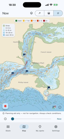
CURRENT MAP OF BOTH BAYS See where it's running and where it's slack: arrows, a colour map by speed, or animated flow.
YOUR OWN SPOTS AND TRACKS Drop your marks on the map or where you stand, with a note and a date (depth, bait, what you caught), or open a GPX file from your plotter, email or Files and pick the ones you want. Current and slack at each one. Hide spots from the map or keep only the ones you follow in the slack list. Record your track on the water and export it as GPX.
BUILT-IN MAP OF BOTH BAYS Depth shading, contours every 5 m and, if you want it, the seabed type (sand, mud, seagrass, reef) and the banks that dry at low tide. All on your phone.
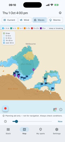
WIND, WAVES AND STORMS — NEXT 48 HOURS Wind and gusts on the map and at every site. Waves in both bays and at the Rip, computed on your phone from the wind, the fetch, the depth, the tide and the current: wind against the ebb at the Heads builds a short, steep sea, and the map shows it. Storm risk from the atmosphere's instability. Checked against the five wave buoys in Port Phillip.
SLACK AND WIND-AGAINST-CURRENT ALERTS Get a heads-up before slack at the sites you pick, and when 10 knots of wind or more will blow against the current. You choose how early.
MELBOURNE TIME, ALWAYS Times are shown in Melbourne time, daylight saving included.
MADE FOR Fishos, scuba divers, freedivers, snorkellers, kayakers and sailors crossing the Rip.
FREE • Current right now, anywhere in Port Phillip and Western Port • Next slack at every site and spot • Your spots and GPX import/export
CURRENTS (PLAN AHEAD) — YEARLY SUBSCRIPTION • Any day, any time: plan tomorrow's trip tonight • Full-day current curve and every slack window • Three-day current map • Slack alerts
Le valutazioni delle persone
Accedi per valutare questa app. Conta essere sinceri.
Ancora nessuna valutazione. L'hai provata? Sii il primo a valutarla.
Altre app di Utilità
Le migliori nuove app di Utilità di questa settimana Drainly: Speaker CleanerMuffled speaker after a splash, rain, or a sweaty workout?
 Photo & PDF Resize: KBFile too large to upload?
 Arvectum Proxy LauncherArvectum Proxy Launcher is a network utility that routes your iPhone through a proxy you…
 Look Twice: Scam & AI CheckLook twice before you click
 Vodoalarm: vodostaji BiHVodoalarm javlja kad tvoja rijeka naglo raste, pa ne moraš stalno gledati vodostaje
 Ham Radio IQHam Radio IQ answers one question: which band is open right now, from where you are, and…