
Tide slink
Ikke hentetPlanning a day on the flats comes down to one question: when exactly is the water low…
Av IGNISHIELD TECH SRL · ProduktivitetHvorfor vi forventer det: Clear, careful description with a well-defined niche audience and a genuinely useful offline tide-window planner.



Om appen
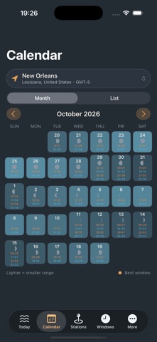
Planning a day on the flats comes down to one question: when exactly is the water low enough, long enough, and in daylight. Tidekeeper answers it without ever touching the network. Today Pick a station and the whole day is laid out: the tide curve drawn from the actual harmonic sum, the next high and low with heights, the dry window around the low, a tide summary, and the moon phase with its position in the spring–neap cycle. Heights are given against the datum you choose — MLLW, LAT, MSL, MLW or your own offset. Windows This is the part that matters for beachcombing, tide pooling, photography, fishing or getting a boat off a ramp. Set a purpose and Tidekeeper finds every stretch of the day that drops below your threshold, lasts at least as long as you need, and falls inside daylight. Six built-in purposes carry sensible defaults; adjust the threshold, minimum duration and daylight rule and they become yours. Each window is scored and ranked, and a safety buffer is trimmed off the end so you are walking back while the water is still below your ankles, not racing it. Calendar A month at a time, with the day's highs and lows and a bar showing where the range sits between springs and neaps. Scan for the week with the biggest daytime low and plan further out. Stations Ninety reference stations across thirty-four countries, searchable by name or region, with tide type, datum and coordinates. You can add your own, or derive a subordinate station from a reference one using time differences and a height ratio — the way paper tide tables have always done it. Reminders and export Ask to be told before the next high or low, when a window opens, or before the turn deadline. Export a two-page A4 tide table for any month: the full daily table, spring–neap bars, and a single day's curve. How it works The tide is expanded into ten constituents — M2, S2, N2, K2, K1, O1, P1, Q1, M4, MS4 — with the Delaunay lunar arguments evaluated at the J2000 epoch. High and low water are found by scanning the curve in three-minute steps and bisecting on its derivative, then refined to a fraction of a minute. Sunrise and sunset come from the same astronomical core, so a daylight-only window means daylight at that station, on that date. Three colour themes, metric or imperial units, station-local or device time, and native charts. Requires iOS 15.0 or later. Coordinates and mean ranges are published figures; constituent amplitudes are derived from mean range and tide type, and epoch phases are synthetic. Predictions are for planning, not for navigation — always check the local tide table and the sky before you go out.
Slik vurderer folk den
Logg inn for å vurdere denne appen. Det ærlige svaret teller.
Ingen vurderinger ennå. Har du prøvd den? Vær den første til å vurdere.
Flere Produktivitet-apper
Ukens beste nye Produktivitet-apper ChickMark: Habit TrackerChickMark is a simple habit tracker for routines, goals, and reminders
 Dayflint: One Thing a DayToo many priorities?
 Snappy Do ItSix connected modes. One traceable journey.
 Fristo CAFMFristo is the app for Fristo CAFM, the facility management software
 UhWhat? Voice NotesCatch the thought before it disappears
- BeginAnywayMorning alarm for hard tasks: set one task, prove you started, build a streak