
HurriMap: Hurricane Tracker
Não reivindicadaHurriMap: Hurricane Tracker When a storm is approaching, every hour matters
Por Ultimate Enterprises LLC · UtilitáriosPorque esperamos isto: Its clear focus on storm alerts for saved places and detailed NHC data make it a practical debut for coastal users.




Em resumo
HurriMap: Hurricane Tracker follows tropical storms and hurricanes across the Atlantic, Gulf, Caribbean and Pacific, with forecast tracks, NHC advisories and satellite imagery. It is aimed at people in storm-prone coastal areas who want alerts for their saved location. It stands out for its wind arrival estimates, including a suggested finish-by time for preparations.
Resumo do Debuts, com base na ficha da App Store.Sobre
HurriMap: Hurricane Tracker
When a storm is approaching, every hour matters. Know where it could go, when winds could reach your area, and which alerts cover your place. HurriMap brings hurricane forecasts, local information and push alerts together so you can spend less time searching and more time preparing.
Don't wait for a warning. Set your place and enable notifications before the next advisory changes your plans.
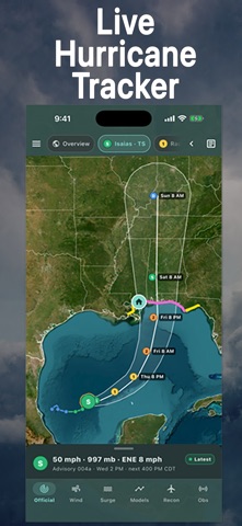
FOLLOW THE STORM • Track hurricanes, tropical storms and developing systems across the Atlantic, Gulf of Mexico, Caribbean, and eastern and central Pacific. • See forecast tracks, the cone of uncertainty, storm history, wind speeds and coastal watches and warnings. • Monitor potential development with two-day and seven-day formation chances. • Read National Hurricane Center advisories, forecast discussions, key messages and hazards. • Explore infrared, visible and water vapor satellite imagery.
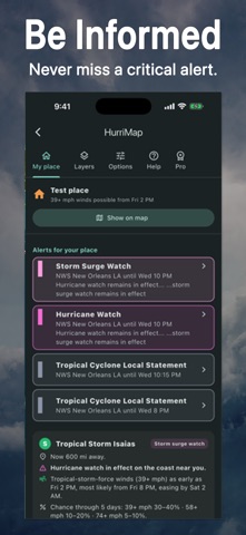
GET ALERTS FOR YOUR PLACE • Receive push notifications for National Weather Service hurricane, tropical storm and storm surge watches and warnings covering your saved place. • Get tornado, extreme wind and flash flood warning notifications with a precise GPS location or map pin. • Choose which alert types you receive. • Read active alerts and local hurricane statements from your area's National Weather Service office. • Set your place using GPS, a map pin or ZIP code. ZIP-based places support tropical alerts; other warning notifications require a precise location.
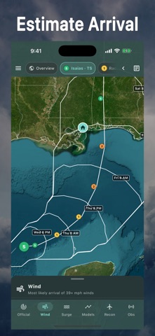
KNOW WHEN TO PREPARE • Check wind chances, forecast closest approach and whether your place falls inside the cone. • See the earliest reasonable and most likely wind arrival times when available. • Explore probabilities and arrival times for 39, 58 and 74 mph winds. • Enter the hours you need to prepare and see a suggested finish-by time based on the earliest reasonable arrival of tropical-storm-force winds. • Explore the changing wind field. Dangerous conditions can extend beyond the center and cone.
FIND LOCAL INFORMATION • Check mapped storm surge risk where coverage is available. • View Florida evacuation zones and reported county evacuation, curfew and re-entry information. • Find nearby open U.S. shelters, with reported pet policies, accessibility and occupancy when available. • Open shelter directions in your maps app. Confirm availability before traveling. • Check buoy and coastal station reports for wind, pressure and waves.
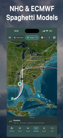
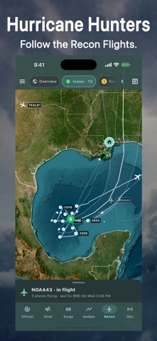
EXPLORE MORE WITH HURRIMAP PRO An optional paid subscription adds: • Spaghetti model tracks and ensemble comparisons. • Intensity charts comparing forecast storm strength. • Hurricane Hunter flight tracks, aircraft positions and reconnaissance observations when available. • Scenario editing: change a storm's path or strength to explore "what if" possibilities. Scenarios are estimates, not forecasts. • An Apple Watch companion and watch-face complications. • Drawing tools to mark up and share maps.
Forecasts, watches and warnings, place alerts, storm surge information, wind arrival times, NHC advisories and My place are free. Pro subscriptions renew automatically until canceled in your App Store account settings.
Download HurriMap today. Make this Hurricane Tracker part of your preparation before a storm threatens.
HurriMap is independent and is not affiliated with or endorsed by NOAA, NHC, NWS or FEMA. Features depend on data availability and coverage. Alerts require internet access and notification permission; delivery is not guaranteed. Keep Wireless Emergency Alerts enabled, use a weather radio and follow local officials and evacuation orders.
Privacy Policy: https://www.hurrimap.com/privacy.html Terms of Use: https://www.hurrimap.com/terms.html
A avaliação das pessoas
Inicia sessão para avaliares esta aplicação. O que conta é seres sincero.
Ainda sem avaliações. Já a experimentaste? Sê o primeiro a avaliar.
Mais apps de Utilitários
As melhores apps novas de Utilitários desta semana Vodoalarm: vodostaji BiHVodoalarm javlja kad tvoja rijeka naglo raste, pa ne moraš stalno gledati vodostaje
 Rokey: Romanian KeyboardType Romanian without worrying about diacritics
 Vibe Island: AI Agent MonitorVibe Island is a command center for the AI coding agents running on your Mac
 Private AuthenticatorPrivate Authenticator keeps your two-factor authentication codes on your own Apple…
 Photo Clean: Photo CleanupA crowded camera roll?
 Songbird AlarmWhat if the morning didn't have to start with a loud noise?