
Seen from Space: Satellite Map
Nicht beanspruchtGoogle and Apple maps show your place as it looked one to three years ago
Von Tigran Barseghyan · DienstprogrammeWarum wir das erwarten: Honest, well-explained description and clear value make this a compelling free tool for curious satellite-imagery explorers.



Kurz gesagt
Seen from Space: Satellite Map shows recent satellite photographs of a saved place, usually taken within days, at 10 m per pixel. It also predicts when the next pass will image that spot and sends a notification before and after. It suits people curious about how land changes, and one notable point is that clouds are not predicted.
Zusammenfassung von Debuts, basierend auf dem Eintrag im App Store.Info
Google and Apple maps show your place as it looked one to three years ago. Seen from Space shows it as it looked a few days ago.
The European Sentinel-2 satellites photograph every spot on land every few days and publish the images free of charge. Seen from Space finds the ones covering your place, shows them at 10 m per pixel usually within hours of the pass, and tells you exactly when the next one will be taken.
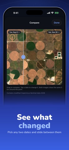
YOUR PLACE, PHOTOGRAPHED AGAIN AND AGAIN - Save any location: your home, your field, a building site, a coastline, a place you miss - See the latest images first, with the cloud cover of each - Compare any two dates with a slider and watch what changed - Zoom to full detail, save to Photos, share
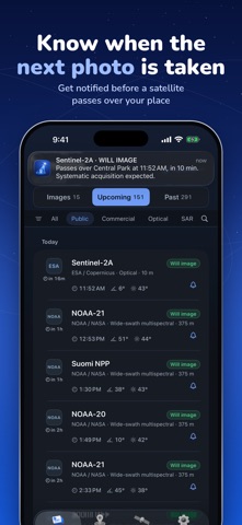
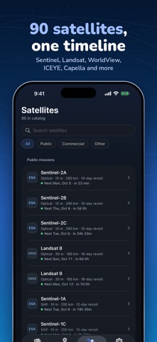
KNOW WHEN THE NEXT IMAGE IS COMING - Pass predictions for 90 Earth-imaging satellites: Sentinel, Landsat, Terra, Aqua, NOAA, WorldView, Pléiades, SkySat, ICEYE, Capella and more - Every pass is sorted into Will image, Could image, or just a pass, from the satellite's swath, pointing limits and the sunlight - A notification before a satellite images your place, and another when the image is in
UNDERSTAND THE PASS - Ground track and swath drawn on the map, to scale - Off-nadir angle, sun elevation, closest approach, altitude - A page for every satellite: sensor, resolution, revisit time, sources
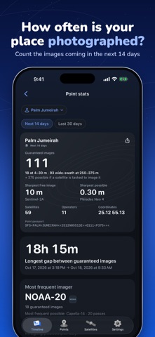
POINT STATS - How many images your place gets in the next two weeks, the longest gap between them, and which satellite images it most
WHAT IT IS NOT - Not live video. No satellite streams the ground, and no app can show it. These are real photographs, each with its date, usually hours to days old. - Not a zoom into your backyard. 10 m per pixel shows roads, fields, blocks and large buildings, and how they change. A car or a tree is smaller than one pixel.
Free: Sentinel-2 and Landsat passes over one place, 7 days of history, the latest images. Pro: all 90 satellites, unlimited places, notifications, 30 days of history, the full gallery, a wider view, compare and export.
Predictions use public orbital elements (SGP4) and each mission's standard acquisition plan; clouds are not predicted. Imagery: Copernicus Sentinel-2 via AWS Open Data. Contains modified Copernicus Sentinel data 2026. Seen from Space is independent and not affiliated with ESA, NASA, USGS or any satellite operator.
Terms of Use: https://developer-barseghyan.github.io/seen-from-space-support/terms Privacy Policy: https://developer-barseghyan.github.io/seen-from-space-support/privacy
Nutzer bewerten sie
Melde dich an, um diese App zu bewerten. Ehrlichkeit zählt.
Noch keine Bewertungen. Hast du die App ausprobiert? Gib die erste Bewertung ab.
Mehr Dienstprogramme-Apps
Die besten neuen Dienstprogramme-Apps dieser Woche Vodoalarm: vodostaji BiHVodoalarm javlja kad tvoja rijeka naglo raste, pa ne moraš stalno gledati vodostaje
 Rokey: Romanian KeyboardType Romanian without worrying about diacritics
 Vibe Island: AI Agent MonitorVibe Island is a command center for the AI coding agents running on your Mac
 Private AuthenticatorPrivate Authenticator keeps your two-factor authentication codes on your own Apple…
 Photo Clean: Photo CleanupA crowded camera roll?
 Songbird AlarmWhat if the morning didn't have to start with a loud noise?