
GPS Altimeter: Elevation Meter
Non rivendicataGPS Altimeter — a GPS elevation meter and barometer built for hiking, trail running…
Di 珊珊 黄 · Viaggi

In breve
GPS Altimeter: Elevation Meter shows live altitude, pressure, coordinates, compass, speed and total ascent using GPS and barometer readings. It is aimed at hikers, trail runners, cyclists, skiers and travelers. A notable feature is the watermark camera, which stamps altitude, place name, GPS and date onto photos.
Riepilogo di Debuts, basato sulla scheda dell'App Store.Informazioni
GPS Altimeter — a GPS elevation meter and barometer built for hiking, trail running, cycling, skiing and travel.
See live altitude, pressure, coordinates, compass, speed and total ascent the moment you open the app. Clear numbers, simple controls, ready for the trail.
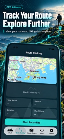
【Key features】 • Live elevation: GPS + barometer fusion, elevation chart, session max and ascent stats • Nearby landmarks: match cities and peaks worldwide so you can compare altitude on the go • Calibration: set a known elevation or QNH sea-level pressure before you climb for steadier readings • Track recording: save elevation profile, distance, duration and map path — with optional background tracking • Watermark camera: stamp altitude, place name, GPS and date on summit photos for easy check-ins • History: keep points and tracks on device; export CSV to review every outing • Units: switch meters / feet to match your preference
【Who it’s for】 Hikers, backpackers, trail runners, ski tourers, cyclists and travelers who want reliable altitude and memorable summit photos.
【Accuracy notes】 GPS elevation varies with satellites, terrain and weather — open sky is usually better. The barometer is excellent for relative ascent; weather changes can shift absolute values, so calibrate when you can. Indoors, tunnels and dense forest may drift. App data is for reference only — use proper maps and gear outdoors, and never stare at your phone on hazardous terrain.
【Privacy】 Core samples and tracks stay on your device by default. Location, camera, photos and tracking permissions are under your control in system Settings.
Download GPS Altimeter and make every climb clearer — and easier to remember.
Le valutazioni delle persone
Accedi per valutare questa app. Conta essere sinceri.
Ancora nessuna valutazione. L'hai provata? Sii il primo a valutarla.
Altre app di Viaggi
Le migliori nuove app di Viaggi di questa settimana ItineroKeep your itinerary and travel details together before, during and after your trip
 HissiFür alle, die auf Aufzüge angewiesen sind: Rollstuhlfahrer:innen, Eltern mit…
 LoungeIQ: Airport LoungesLoungeIQ tells you which airport lounges you can actually get into
 FjellFjell answers one question: how long would it take to walk there?
 Leave the ResortLeave the Resort is the travel app that stops you getting ripped off
 Schengen Days: 90/180 PlannerJust enter your entry and exit dates