
Seen from Space: Satellite Map
Ikke hentetGoogle and Apple maps show your place as it looked one to three years ago
Av Tigran Barseghyan · VerktøyHvorfor vi forventer det: Honest, well-explained description and clear value make this a compelling free tool for curious satellite-imagery explorers.



Kort fortalt
Seen from Space: Satellite Map shows recent satellite photographs of a saved place, usually taken within days, at 10 m per pixel. It also predicts when the next pass will image that spot and sends a notification before and after. It suits people curious about how land changes, and one notable point is that clouds are not predicted.
Sammendrag fra Debuts, basert på oppføringen i App Store.Om appen
Google and Apple maps show your place as it looked one to three years ago. Seen from Space shows it as it looked a few days ago.
The European Sentinel-2 satellites photograph every spot on land every few days and publish the images free of charge. Seen from Space finds the ones covering your place, shows them at 10 m per pixel usually within hours of the pass, and tells you exactly when the next one will be taken.
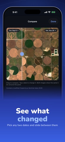
YOUR PLACE, PHOTOGRAPHED AGAIN AND AGAIN - Save any location: your home, your field, a building site, a coastline, a place you miss - See the latest images first, with the cloud cover of each - Compare any two dates with a slider and watch what changed - Zoom to full detail, save to Photos, share
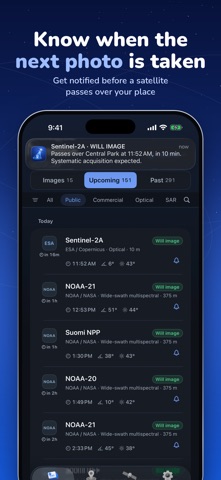
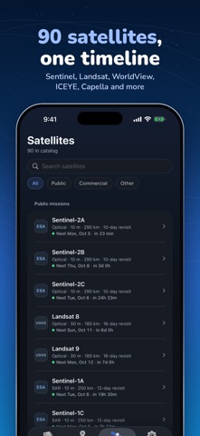
KNOW WHEN THE NEXT IMAGE IS COMING - Pass predictions for 90 Earth-imaging satellites: Sentinel, Landsat, Terra, Aqua, NOAA, WorldView, Pléiades, SkySat, ICEYE, Capella and more - Every pass is sorted into Will image, Could image, or just a pass, from the satellite's swath, pointing limits and the sunlight - A notification before a satellite images your place, and another when the image is in
UNDERSTAND THE PASS - Ground track and swath drawn on the map, to scale - Off-nadir angle, sun elevation, closest approach, altitude - A page for every satellite: sensor, resolution, revisit time, sources
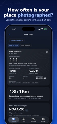
POINT STATS - How many images your place gets in the next two weeks, the longest gap between them, and which satellite images it most
WHAT IT IS NOT - Not live video. No satellite streams the ground, and no app can show it. These are real photographs, each with its date, usually hours to days old. - Not a zoom into your backyard. 10 m per pixel shows roads, fields, blocks and large buildings, and how they change. A car or a tree is smaller than one pixel.
Free: Sentinel-2 and Landsat passes over one place, 7 days of history, the latest images. Pro: all 90 satellites, unlimited places, notifications, 30 days of history, the full gallery, a wider view, compare and export.
Predictions use public orbital elements (SGP4) and each mission's standard acquisition plan; clouds are not predicted. Imagery: Copernicus Sentinel-2 via AWS Open Data. Contains modified Copernicus Sentinel data 2026. Seen from Space is independent and not affiliated with ESA, NASA, USGS or any satellite operator.
Terms of Use: https://developer-barseghyan.github.io/seen-from-space-support/terms Privacy Policy: https://developer-barseghyan.github.io/seen-from-space-support/privacy
Slik vurderer folk den
Logg inn for å vurdere denne appen. Det ærlige svaret teller.
Ingen vurderinger ennå. Har du prøvd den? Vær den første til å vurdere.
Flere Verktøy-apper
Ukens beste nye Verktøy-apper Vodoalarm: vodostaji BiHVodoalarm javlja kad tvoja rijeka naglo raste, pa ne moraš stalno gledati vodostaje
 Rokey: Romanian KeyboardType Romanian without worrying about diacritics
 Vibe Island: AI Agent MonitorVibe Island is a command center for the AI coding agents running on your Mac
 Private AuthenticatorPrivate Authenticator keeps your two-factor authentication codes on your own Apple…
 Photo Clean: Photo CleanupA crowded camera roll?
 Songbird AlarmWhat if the morning didn't have to start with a loud noise?