
Tapu Sepeti
Not claimedTapu Sepeti keeps all your deeds at your fingertips
By BILAL ENES FEDAR · TravelWhy we expect it: Clear, well-organised description and ten screenshots make its parcel lookup and satellite history value easy to grasp.




About
Tapu Sepeti keeps all your deeds at your fingertips. Find your parcel in Türkiye using the public parcel-query data of TKGM (the Turkish Land Registry and Cadastre), see its boundary on a satellite map, and look back through the satellite archive to see how the land changed over the years.
FIND YOUR PARCEL EASILY • Pick the province, district and neighbourhood, then enter the block (ada) and parcel (parsel) number • Type an address to find the nearest parcel • Search by latitude/longitude • Tap any point on the map to fetch the parcel there • On the land? "Parcel at my location" looks it up with one tap
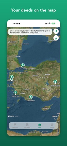
ALL YOUR DEEDS IN ONE PLACE • Save parcels, give them names like "Village field" and add your own notes • Sort your deeds by newest, name or area; export them all as one KML/GeoJSON file • See your saved deeds in a list and together on the map • Summary of your deed count and total area • Parcels you look up are kept on your device, so reopening them needs no new query • Refresh the latest TKGM data with one tap
SATELLITE HISTORY • Scan the Esri World Imagery Wayback archive for images of your parcel taken on different dates • Slide to see how the land changed over the years (e.g. from 2014 to 2025) • The parcel boundary is drawn on every image • The Overview tells you when newer satellite imagery is published where your saved deeds are
FIND YOUR WAY ON SITE • Parcel boundary and numbered corner points on a satellite map • Compass: direction and distance to the parcel's centre and corners • AR: see the corner points approximately through the camera on phones with precise location • 3D view • Directions in Apple Maps
DETAILED INFORMATION • Province, district, neighbourhood, block, parcel, sheet, locality and land use • Registered area and computed area (m² and dönüm), perimeter • The parcel's TKGM history (the parcels it was split into and why) • Share as text with a map link, or export as GeoJSON or KML
PRIVACY FIRST • No account, no ads, no tracking • Your saved deeds stay on your device • Turkish and English
IMPORTANT Tapu Sepeti shows public parcel-query data from TKGM (Tapu ve Kadastro Genel Müdürlüğü). It is not affiliated with TKGM or any government agency and is not an official app. Information is for reference only and must not be used for official procedures, sales or legal matters. Locations, compass and AR views are approximate; for exact boundaries consult a licensed surveyor. Satellite history imagery comes from Esri World Imagery Wayback (Esri, Maxar, Earthstar Geographics).
People rate it
Sign in to rate this app. Honest is what counts.
No ratings yet. Tried it? Be the first to rate it.
More Travel apps
Best new Travel apps this week HissiFür alle, die auf Aufzüge angewiesen sind: Rollstuhlfahrer:innen, Eltern mit…
 Leave the ResortLeave the Resort is the travel app that stops you getting ripped off
 Schengen Days: 90/180 PlannerJust enter your entry and exit dates
 Trova Treasure HuntsTurn a walk through the city into a treasure hunt
 LeaveTime — When to LeaveLeaveTime answers one question: what time do I need to leave to make my flight?
 MapTogether: Group TravelStop juggling one app for the plan, another for splitting costs, another for photos, and…