
MavGCS
Nicht beanspruchtMavGCS is a ground control station for drones and model aircraft that use the MAVLink…
Von Derin Hakan Karakurt · Reisen



Info
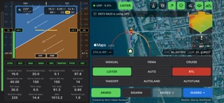
MavGCS is a ground control station for drones and model aircraft that use the MAVLink protocol: ArduPilot, PX4 and INAV. Connect your iPhone to your aircraft's telemetry and see everything that matters on one landscape screen.
No drone at hand? Open Settings, choose Demo and tap Connect: a simulated aircraft takes to the air so you can try every screen and button.
FLIGHT INSTRUMENTS • Artificial horizon with airspeed and altitude tapes, heading, climb rate, throttle and wind • Battery voltage, current and remaining charge, with a battery gauge • Systems panel: gyro, accelerometer, compass, barometer, GPS, rangefinder, airspeed and EKF, each green, yellow or red • EKF and vibration health at a glance • Sixteen live readings: speeds, altitude, distances, satellites, attitude, wind and pressure
MAP • Satellite imagery, with place names and roads in Hybrid view • The aircraft, home and the path flown, with lines for heading, track, where it is steering and where it will be • Weather radar for 50 km around the aircraft • Terrain is kept on your phone, so the terrain instruments work without a signal; choose how much in Settings
TERRAIN AWARENESS • Terrain radar: the ground ahead, coloured by how much clearance there is • Live AGL: the ground along your track, your height above it now and the smallest gap ahead • Compass rose showing the way home, your course over the ground and the wind
CONTROL • Arm and disarm with hold-to-confirm buttons • Change flight modes, fly to any point by tapping the map, and set speed, altitude and loiter radius • Choose how often telemetry is sent, to suit slow radio links • ETA to the next waypoint, and directions to the aircraft in Google Maps
CONNECTS OVER • UDP or TCP: WiFi telemetry bridges such as mLRS and ELRS, LTE telemetry, or a simulator (SITL)
MavGCS is open source (GPL-3.0). Always fly within the law and keep your aircraft in sight: MavGCS is an aid, not a certified navigation or collision-avoidance system.
Created by Derin Hakan Karakurt.
Nutzer bewerten sie
Melde dich an, um diese App zu bewerten. Ehrlichkeit zählt.
Noch keine Bewertungen. Hast du die App ausprobiert? Gib die erste Bewertung ab.
Mehr Reisen-Apps
Die besten neuen Reisen-Apps dieser Woche ItineroKeep your itinerary and travel details together before, during and after your trip
 HissiFür alle, die auf Aufzüge angewiesen sind: Rollstuhlfahrer:innen, Eltern mit…
 FjellFjell answers one question: how long would it take to walk there?
 Leave the ResortLeave the Resort is the travel app that stops you getting ripped off
 Schengen Days: 90/180 PlannerJust enter your entry and exit dates
 Trova Treasure HuntsTurn a walk through the city into a treasure hunt