
Preflight Lens
Sin reclamarPreflight Lens presents a new way for airline pilots to review relevant flight data…
De LAURENT LANGLA · Viajes



En resumen
Preflight Lens is a flight review app for airline pilots. It gathers NOTAMs, METARs, TAFs, approach minima, the likely runway in use, and turbulence at cruise level for a chosen flight, which can be entered by airline and flight number or by departure, destination and alternate. What stands out is that it places each NOTAM in the flight phase it affects and colours it by consequence.
Resumen de Debuts, basado en la ficha de la App Store.Acerca de
Preflight Lens presents a new way for airline pilots to review relevant flight data: NOTAMs, METARs and TAFs, approach minima, the most likely runway in use, turbulence at your cruise level, and the flight level that pays. Enter your airline and flight number, or simply your departure, destination and alternate.
YOUR FLIGHT • Your roster picks it (Premium): today's and tomorrow's flights, read from your phone calendar on this device. • Pick your airline by its logo and type the flight number: departure, destination and today's schedule fill themselves. • You can also select your flight from all your airline’s departures at your airport. • A destination alternate is proposed from nearby civil aerodromes that are open by NOTAM, long enough and above minima at your landing time. A take-off alternate when the departure needs one. The final choice is yours.
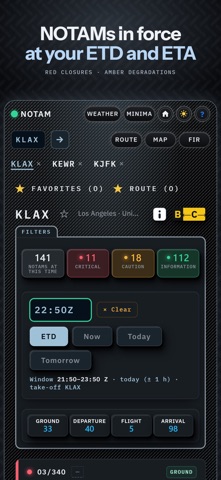
NOTAM • Filtered to your take-off and arrival window, and coloured by consequence: closures and prohibitions in red, degraded aids in amber, the rest in green. A closure that has been lifted reads as reopened. • Each NOTAM placed in the phase it affects: ground, departure, flight, arrival. • Q-codes decoded, abbreviations explained on tap, long NOTAMs reduced to a clear summary. The raw text stays, exactly as issued. • Airfield layout with closed runways and taxiways drawn where they are. • FIR NOTAMs: closed FIRs in red, restricted but crossable ones in amber.
WEATHER • METARs and TAFs colour-coded for your ETD and ETA, with windshear, fog, thunderstorms, CBs and other hazardous phenomena clearly highlighted. • The estimated runway in use, from recently observed traffic, wind, preferential runways and NOTAMs affecting runways and approach aids. • Headwind, tailwind and crosswind components for every runway, plus the maximum wind component expected during the day.
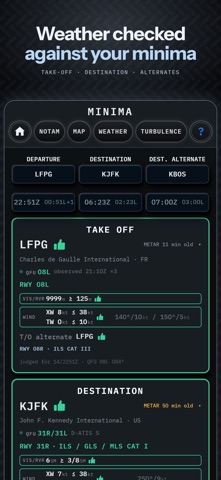
MINIMA • Take-off, destination and alternates: each runway checked against minima at the estimated time, for visibility or RVR, ceiling, crosswind and tailwind, with the NOTAMs in force quoted where they change the answer. • Enter or verify the minima against your airline's latest documentation. Preflight Lens provides the comparison; the minima and the final assessment remain your responsibility.
MAP • Every aerodrome coloured by visibility and ceiling, a ring when the TAF turns worse, a bolt for CBs. • Surface wind on each runway, now and up to three hours ahead. • Rain: radar for Europe, North America and Japan, a satellite estimate elsewhere, with the thunderstorm SIGMETs in force. • Model turbulence at your flight level, and your route drawn along the track typically flown on this city pair.
TURBULENCE • The forecast along your route, minute by minute, at your cruise level, each point read at the hour you will be there, on the EDR scale pilots use. Turbulence SIGMETs on top.
TIME AND FUEL • Compare cruise levels: the wind gain at each level, and the time and fuel against a reference, so you see which level is faster and which one burns less.
BUILT FOR THE COCKPIT • It flies offline. Load your route before departure and the whole briefing stays on board: NOTAM, weather, airfield charts, turbulence grid, FIR boundaries. Every reading shows when it was taken. • Dark by default, readable at night, with a day theme for the ramp. On iPhone and iPad.
NOT AN OFFICIAL SOURCE Preflight Lens is designed to enhance situational awareness. It does not replace your official pre-flight briefing or your company's operational documentation. Terms of Use: https://preflightlens.com/legal.html Privacy Policy: https://preflightlens.com/legal.html#privacy
Así la valora la gente
Inicia sesión para valorar esta app. Lo que cuenta es ser sincero.
Aún no hay valoraciones. ¿La has probado? Sé el primero en valorarla.
Más apps de Viajes
Las mejores apps nuevas de Viajes esta semana ItineroKeep your itinerary and travel details together before, during and after your trip
 HissiFür alle, die auf Aufzüge angewiesen sind: Rollstuhlfahrer:innen, Eltern mit…
 FjellFjell answers one question: how long would it take to walk there?
 Leave the ResortLeave the Resort is the travel app that stops you getting ripped off
 Schengen Days: 90/180 PlannerJust enter your entry and exit dates
 Trova Treasure HuntsTurn a walk through the city into a treasure hunt