
MavGCS
NieodebranaMavGCS is a ground control station for drones and model aircraft that use the MAVLink…
Twórca: Derin Hakan Karakurt · Podróże



O aplikacji
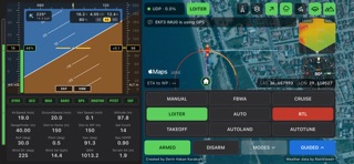
MavGCS is a ground control station for drones and model aircraft that use the MAVLink protocol: ArduPilot, PX4 and INAV. Connect your iPhone to your aircraft's telemetry and see everything that matters on one landscape screen.
No drone at hand? Open Settings, choose Demo and tap Connect: a simulated aircraft takes to the air so you can try every screen and button.
FLIGHT INSTRUMENTS • Artificial horizon with airspeed and altitude tapes, heading, climb rate, throttle and wind • Battery voltage, current and remaining charge, with a battery gauge • Systems panel: gyro, accelerometer, compass, barometer, GPS, rangefinder, airspeed and EKF, each green, yellow or red • EKF and vibration health at a glance • Sixteen live readings: speeds, altitude, distances, satellites, attitude, wind and pressure
MAP • Satellite imagery, with place names and roads in Hybrid view • The aircraft, home and the path flown, with lines for heading, track, where it is steering and where it will be • Weather radar for 50 km around the aircraft • Terrain is kept on your phone, so the terrain instruments work without a signal; choose how much in Settings
TERRAIN AWARENESS • Terrain radar: the ground ahead, coloured by how much clearance there is • Live AGL: the ground along your track, your height above it now and the smallest gap ahead • Compass rose showing the way home, your course over the ground and the wind
CONTROL • Arm and disarm with hold-to-confirm buttons • Change flight modes, fly to any point by tapping the map, and set speed, altitude and loiter radius • Choose how often telemetry is sent, to suit slow radio links • ETA to the next waypoint, and directions to the aircraft in Google Maps
CONNECTS OVER • UDP or TCP: WiFi telemetry bridges such as mLRS and ELRS, LTE telemetry, or a simulator (SITL)
MavGCS is open source (GPL-3.0). Always fly within the law and keep your aircraft in sight: MavGCS is an aid, not a certified navigation or collision-avoidance system.
Created by Derin Hakan Karakurt.
Oceny użytkowników
Zaloguj się, aby ocenić tę aplikację. Liczy się szczerość.
Brak ocen. Znasz tę aplikację? Oceń ją jako pierwszy.
Więcej aplikacji z kategorii Podróże
Najlepsze nowe aplikacje z kategorii Podróże w tym tygodniu ItineroKeep your itinerary and travel details together before, during and after your trip
 HissiFür alle, die auf Aufzüge angewiesen sind: Rollstuhlfahrer:innen, Eltern mit…
 FjellFjell answers one question: how long would it take to walk there?
 Leave the ResortLeave the Resort is the travel app that stops you getting ripped off
 Schengen Days: 90/180 PlannerJust enter your entry and exit dates
 Trova Treasure HuntsTurn a walk through the city into a treasure hunt